A Bit of Geography, History, Flora/Fauna and Weather Lore
by Paul E. Carrigan; with additions by Ed Sawicki
Note: The Russian landmass is not shown in the above map.
The Aleutians are the northernmost of a chain of islands that rims the extremely deep waters of the Pacific basin from north through west. Mostly of volcanic origin, these islands include the Philippines, Ryukyu Islands, Japanese Islands, and Kurile Islands. All of these, including Siberia’s Kamchatka Peninsula and the Alaska Peninsula, are noted for their active volcanoes which periodically erupt, and for frequent earthquakes many of which create seismic tidal waves, called tsunamis.
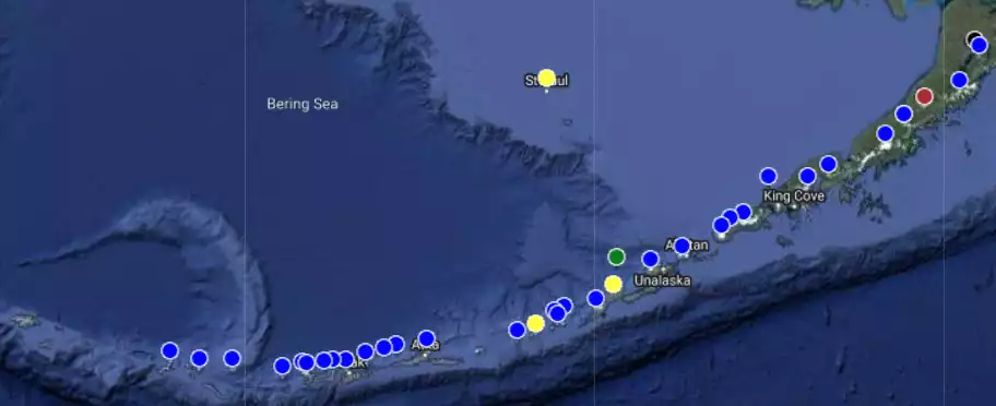
The map above shows the locations of the volcanoes in the Aleutian Islands and a portion of the Alaska Peninsula. The blue dots are stratovolcanoes.
The eastern end of the Aleutians begins on the west side of Isanotski Pass, (False Pass), which separates them from the southwestern tip of the Alaska Peninsula. Like the blade of a scimitar, they curve westward in a thousand mile arc toward Kamchatka. They terminate at the Aleutian’s westernmost island of Attu. This arc forms a dividing line between the deep waters of the North Pacific Ocean on the south and the shallower waters of the Bering Sea on the north.
A word about that arc: Although it appears that islands are at different latitudes, this is because the map is a two-dimensional rendering of the Earth's surface which is a spheroid. The table below shows the latitudes for the major Aleutian islands from west to east. The western islands are within one degree of latitude of one another—they're in more of a straight line than an arc.
| Attu | 52.8 |
| Shemya | 52.7 |
| Kiska | 52.0 |
| Semisopochnoi | 51.9 |
| Adak | 51.9 |
| Atka | 52.1 |
| Nikolski | 52.9 |
| Dutch Harbor | 53.9 |
| Cold Bay | 55.2 |
There are four major island groups within the Aleutians. From east to west they are: The Fox Islands, Andreanof Islands, Rat Islands, and Near Islands. There are also four lesser groups, namely: The Krenitzin Islands, Islands of Four Mountains, Delarof Islands, and Semichi Islands. Perhaps one-hundred twenty-five large and small islands make up these various groups. In addition there are numerous individual, named islands both large and small not included in the above groups. Hundreds of tiny islands more properly classified as rocks and reefs are also present.
Following is an east to west listing of significant Aleutian Islands with their highest points. In many cases, these highest points are unnamed.
| Fox Islands | |
| Tigalda | 1682 feet |
| Avatanak | 1635 feet |
| Rootok | 1545 feet |
| Akun | Mt Gilbert 2620 feet |
| Akutan | 3275 feet |
| Unalqa | 722 feet |
| Sedanka | 2130 feet |
| Unalaska | Mt Makushin 6680 feet |
| Umnak | Mt. Vsevidof 7051 feet |
| Islands of Four Mountains | |
| Kaqamil | Kagamil volcano 2910 feet |
| Chuginadak | Mt. Cleveland 5675 feet |
| Carlisle | Mt Carlisle 5283 feet |
| Herbert | Herbert Volcano 4225 feet |
| Yunaska | 3119 feet |
| Chagulak | 3750 feet |
| Amukta | 3663 feet |
| Seguam | Pyre Peak 3458 feet |
| Andreanof Islands | |
| Amlia | 2100 feet |
| Atka | Mt Korovin 5030 feet |
| Umak | 2045 feet |
| Little Tanaga | 1747 feet |
| Great Sitkin | 5710 feet |
| Kagalaska | 2495 feet |
| Adak | Mt Moffett 3924 feet |
| Kanaga | Mount Kanaga 4287 feet |
| Tanaga | Tanaga 5924 feet |
| Ogliuga | 82 feet |
| Skagul | 39 feet |
| Kavalga | 130 feet |
| Ulak | 302 feet |
| Gareloi | Mt Gareloi 5161 feet |
| Amatignak | 1875 feet |
| Rat Islands | |
| Semisopochnoi | Anvil Peak 4007 feet |
| Amchitka | 1225 feet |
| Segula | Segula Peak 3783 feet |
| Hawadax | 1125 feet |
| Little Sitkin | 3897 feet |
| Kiska | Kiska Volcano 4006 feet |
| Buldir | Buldir Volcano 2175 feet |
| Near Islands | |
| Shemya | |
| Nizki | 165 feet |
| Alaid | 662 feet |
| Agattu | 2080 feet |
| Attu | 3100 feet |
Unalaska, Umnak, Amlia, Atka, Adak, Kanaga, Tanaga, Amchitka, Kiska, Agattu, and Attu are considered as the large Aleutian Islands. They range in length from Kiska’s 25 miles to 80 miles for Unalaska. The larger islands are generally extremely irregular in shape because of the numerous fjord-like bays that indent their rugged coastlines. Unalaska, for example, ranges in width near its middle from four miles to twenty-five miles. An average width for the major islands might be twelve miles.
At extreme ends of configuration are Semisopochnoi and Amchitka. Surprisingly, they are only thirty-five miles apart. Amchitka is relatively low and flat except at its northwestern end. Although it is forty miles long it has a fairly uniform width of only about four miles. Nearby Semisopochnoi, on the other hand, is a circular, four-thousand-foot mountain peak with no deep bays indenting its average twelve mile width.
The Aleutians lie almost totally between the latitudes 51 degrees and 54 degrees North. If you were to fly around the globe in this narrow belt, you would pass over the tip of Siberian Kamchatka; through the Sea of Okhotsk; catch the northern tip of Sakhalin Island; nip northernmost Manchuria; pass north of Mongolia and the Gobi Desert; cross the Steppes of U.S.S.R.; pass slightly south of Moscow; north of Warsaw, Poland; over Berlin, Amsterdam, London, Dublin; across the North Atlantic Ocean south of Iceland and Greenland; make landfall on the North American continent near Goose Bay, Labrador; touch the south end of Hudson's Bay; fly over Lake Winnepeg; Saskatoon, Saskatchewan; Banff, Alberta; emerge over the North Pacific Ocean between Prince Rupert, B.C. and the Queen Charlotte Islands; then fly across the Gulf of Alaska back to Dutch Harbor.
Although these are northern latitudes, the temperatures of the Aleutians are moderate and the range small. The winter average is about 33 degrees Fahrenheit and the summer 50 degrees. Temperatures as low as zero have never been recorded in the Aleutians. These uniform temperatures of the Aleutians are caused by the warming waters of the great Kuroshio or Japanese current that flows eastward south of the Aleutians.
Although treeless, the Aleutians are not barren. Grasses, plants, and wild flowers in profusion spring to life at the lower elevations in late summer. This vegetation fairly explodes. Mother Nature seems to try to pack a full year’s growth into the short available season. The islands also abound with animal life. Countless seabirds of many kinds make the Aleutians their permanent home. Various other birds by the millions stop over briefly in the Aleutians on their yearly migrations.
Surrounding seas contain a large variety and great numbers of fishes, mollusks, and other invertebrates as well as whales, seals, sea lions and sea otters. It was this abundance of animal life and the assurance of a food supply that attracted the first Aleuts to settle in these islands. This food supply was sufficient to support, at one time, an Aleut population estimated at 20,000 to 25,000.
In the early 1740's, Vitus Bering, a Danish explorer in the employ of Russian Czar Peter the Great sailed from Kamchatka on a voyage of discovery during which he found the Aleutians. Bering’s voyage was quickly followed by those of the Promyshlenniki, adventurous, ruthless fur hunters from Kamchatka and Siberia who were seeking riches. During the next half century, the Promyshlenniki swept over the Aleutians like locust and carried their terror as far east as Kodiak. Everywhere they set foot they raped, pillaged, and persecuted. Peaceful Aleuts by the thousands were murdered. Surviving Aleuts were enslaved. White man’s diseases were introduced which further decimated the Aleut population.
When I reached the Aleutians in early 1942, the resident native population was less than one thousand. About seven hundred of this number lived in the eastern Aleutians and in the Pribilof Islands of the southern Bering Sea. There were native villages on the Pribilof Islands of St. Paul and St. George; Trident Bay on Akutan Island; Biorka on Sedanka Island; Unalaska, Makushin, and Kashega on Unalaska Island. Farther west there were less than two hundred. About seventy natives lived at Nikolski on Umnak Island, approximately the same number at Nazan Bay, Atka Island, and about forty at Chichagof on far off Attu.
There were no longer any established Aleut villages in the 550-mile stretch between Nazan Bay, Atka and Attu. A few hardy native fur trappers, however, pursued their winter trade on some of the larger islands between.
Islands of the Bering Sea have a place in this story so they should be located for the reader. North from the Aleutians one first encounters tiny Bogoslof Island; the island of mystery. This active volcanic peak is located about sixty-two miles west of Dutch Harbor and twenty-seven miles due north of the northeastern tip of Umnak Island. St. George, southernmost of the Pribilof Islands, is about 210 miles northwest of Dutch Harbor. Fifty miles beyond is St. Paul Island. Nunivak Island lies about 30 miles off Alaska’s mainland and approximately 225 miles north-northeast of St. Paul. One hundred seventy five miles almost due west of Nunivak is St. Matthew Island. About 200 miles north of St. Matthew and 150 miles southwest of Nome is St. Lawrence Island. Tiny King Island lies approximately 100 miles north northeast of St. Lawrence. Last we come to Little Diomede Island which sits in the middle of the Bering Strait and about 75 miles northwest of King Island. Little Diomede is about one mile from Big Diomede, which belongs to Russia.
Native Eskimos inhabit Little Diomede, King, St. Lawrence and Nunivak. St. Matthew Island was uninhabited. The natives on St. Paul and St. George are Aleuts. Their ancestors had been forcibly removed from Aleutian Islands in the late 1700's by the Promyshlenniki and placed on the previously uninhabited Pribilofs to harvest sea otter and fur seal pelts.
About five months out of each year the Bering Sea is locked in pack-ice from the vicinity of the Pribilofs north. Pack-ice or bergs seldom, if ever, come within two hundred miles of the Aleutians.
The reader should not be misled by the seemingly mild range of temperatures in the Aleutians. The warmer waters and moisture laden air associated with the Japanese current meet the relatively drier air of icy winds blowing off eastern Siberia and the much colder waters of the Bering Sea in this region. There is also a smaller, ice-cold, Oyashio current that sweeps southwestward out of the western Bering Sea down along the east side of Kamchatka Peninsula and the Kurile Islands. The collision of these contrasting forces creates a perfect weather factory, which produces dense fog, rain, snow, sleet and winds frequently well in excess of 100 knots (115 mph). Winds over 200 mph were recorded at Attu in early 1945.
In addition, the Aleutians are plagued by "Williwaws" which are sudden downdrafts of cold, dense air. These sharp edged gusts rush down the lee side from mountain peaks and passes. Winds can be almost calm one moment then be shrieking over 100 knots the next. Williwaws are created when cold, dense, heavy air becomes dammed up behind mountains. Forced aloft, small parcels spill over through saddles much the same as water would flow over a low portion of a dam. In their haste to seek sea level, these small packages of dynamite accelerate downward from the heights until they hit the surface where their energy is expended in what can only be described as the destructive force of an explosion. Williwaws are most prevalent in the fall, winter, and spring.
Fog, rain, sleet and snow accompanied by violent winds can occur during any season. It is for this reason that, in weather circles, the Aleutians are generally considered to have the worst weather in the world. It is granted that this fact plus their remoteness might make the Aleutians an intriguing place to visit briefly but it was a cheerless, unpleasant place to live and an exceedingly difficult place to wage war.
Born of violence, troubled, restless, the Aleutians have been described as a fiery necklace on the exposed throat of Alaska. During WWII they also became a two-way bridge of stepping stones between Alaska and Japan.